
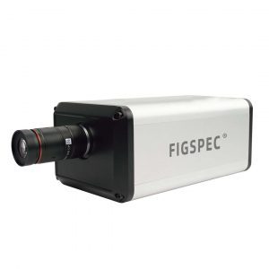
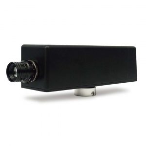
Lidar UAV hyperspectral system FS60-UCR
Views: 394
The FS60-UCR series Lidar UAV hyperspectral system is a multifunctional unmanned aerial vehicle detection device that integrates lidar and hyperspectral imaging to obtain lidar and hyperspectral image data.
Description
The main functions include: hyperspectral imaging, with a spectral range of 400-1700nm; a multi-threaded lidar with a ranging distance of up to 300m; an ultra-clear preview camera; a built-in control system in the host; high-precision inertial navigation and solid-state storage. It is suitable for being carried by various drones.
- Spectral range: 400-1700nm
- Spectral resolution: better than 2.5nm
- Spatial pixel count: 1920
- High-precision multi-threaded lidar synchronous measurement
- Ranging distance: 300m
- Mounted on DJI M350/300 to measure large-area data images.
- Equipped with acquisition and analysis software.
Specifications
| Feature | FS-62UCR | FS-60UCR | FS-64UCR |
|---|---|---|---|
| Spectral Splitting Method | Transmission grating spectral splitting | Same as FS-62UCR | Same as FS-62UCR |
| Spectral Range | 900-1700nm | 400-1000nm | 400-1700nm |
| Spectral Bands | 1024 | 1200 | 250 |
| Spectral Resolution | 6.5nm | 2.5nm | 18nm |
| Slit Width | 25µm | 5.86µm x 5.86µm | 5µm x 5µm |
| Spectral Efficiency | >60% | Same as FS-62UCR | Same as FS-62UCR |
| Stray Light | <0.5% | Same as FS-62UCR | Same as FS-62UCR |
| Spatial Pixel Count | 1280 | 1920 | Same as FS-62UCR |
| Pixel Size | Same as FS-62UCR | 5.86µm x 5.86µm | Same as FS-62UCR |
| Imaging Speed | Full band 70Hz | Full band 128Hz | Full band 200Hz |
| Detector | InGaAs | CMOS | InGaAs |
| SNR (Peak) | 600/1 | 600/1 | Same as FS-62UCR |
| Camera Output Interface | C-Mount | USB or Gigabit Ethernet | USB |
| Camera Lens Interface | C-Mount | Same as FS-62UCR | Same as FS-62UCR |
| Built-in Embedded Data Acquisition and Processing | Embedded processor with 512GB SSD storage | Same as FS-62UCR | Same as FS-62UCR |
| Heat Dissipation Method | Internal air cooling | Same as FS-62UCR | Same as FS-62UCR |
| Spectral Camera Size | 135mm x 82mm x 100mm (L x W x H) | 155mm x 95mm x 119mm (L x W x H) | Same as FS-62UCR |
| Accessories | Reflectance calibration plate | Same as FS-62UCR | Same as FS-62UCR |
| Focal Length of Spectral Camera Lens | 25mm | Same as FS-62UCR | Same as FS-62UCR |
| Field of View of Spectral Camera Lens | >25° | Same as FS-62UCR | Same as FS-62UCR |
| Measurement Accuracy of Lidar System | 5cm | Same as FS-62UCR | Same as FS-62UCR |
| Lidar Ranging Distance | 300m | Same as FS-62UCR | Same as FS-62UCR |
| Lidar Scanning Field of View Angle | 40.3° (vertical) x 360° (horizontal) | Same as FS-62UCR | Same as FS-62UCR |
| Lidar Point Frequency | 640,000 points/second (single echo), 1,280,000 points/second (double echo), 1,920,000 points/second (triple echo) | Same as FS-62UCR | Same as FS-62UCR |
| Lidar Built-in Camera Pixel | 26 million (6252 x 4168) | Same as FS-62UCR | Same as FS-62UCR |
| Lidar Lens Focal Length | 16mm | Same as FS-62UCR | Same as FS-62UCR |
| Flight Platform | DJI M350 RTK / M300 RTK | Same as FS-62UCR | Same as FS-62UCR |
| Aircraft Size (Unfolded) | 810mm x 670mm x 430mm (without blades) | Same as FS-62UCR | Same as FS-62UCR |
| Aircraft Size (Folded) | 430mm x 420mm x 430mm (with blades) | Same as FS-62UCR | Same as FS-62UCR |
| Aircraft Weight | Empty aircraft without battery: 3.77kg; Empty aircraft with battery: 6.47kg | Same as FS-62UCR | Same as FS-62UCR |
| Maximum Takeoff Weight of Aircraft | 9.2kg | Same as FS-62UCR | Same as FS-62UCR |
| Fastest Ascent Speed of Aircraft | 6m/s | Same as FS-62UCR | Same as FS-62UCR |
| Maximum Horizontal Flight Speed of Aircraft | 23m/s | Same as FS-62UCR | Same as FS-62UCR |
| Longest Flight Time | 55 minutes (windless conditions, forward flight at 8m/s, until battery reaches 0%) | Same as FS-62UCR | Same as FS-62UCR |
| Operation Mode | Easy to operate. No professional drone operator is required. Single-person operation can be realized | Same as FS-62UCR | Same as FS-62UCR |
| Observation Mode | Real-time observation of the aircraft sampling location, hyperspectral image, and spectral data through the ground station. | Same as FS-62UCR | Same as FS-62UCR |
| Correction Mode | Radiance correction, reflectance correction, and area correction; supports batch processing | Same as FS-62UCR | Same as FS-62UCR |
| Data Format | Compatible with SPE format, HDR format, and SCP format | Same as FS-62UCR | Same as FS-62UCR |
| Application Software | FIGSPEC UAV, FIGSPEC Merage Mosaic Software, FIGSPEC Studio Application Software, Image Analysis Software | Same as FS-62UCR | Same as FS-62UCR |
Applications
Airborne Hyperspectral Camera Mining Test
The UAV hyperspectral imaging system can quickly collect high-resolution images of the surface by carrying a hyperspectral sensor, capturing the spectral characteristics of different minerals. This enables explorers to quickly identify potential ores and mineralized zones, greatly improving exploration efficiency.
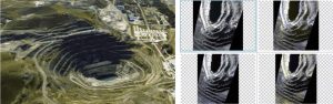
After analyzing the collected data, we get the above group of pictures under
different bands.
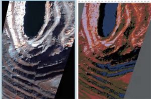
The above unsupervised clustering algorithm image is obtained through analysis software
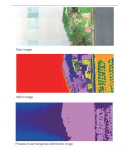
Use Airborne Hyperspectral Camera to Photograph Ponds to Obtain NDVI Images and Images of Potassium Permanganate Distribution in the Water
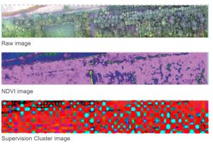
NDVI Image Analysis and Supervised Clustering after Photographing the Forest Using Airborne Hyperspectral Camera


Reviews
There are no reviews yet.